


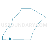
FORESTVILLE - T 2 Voting District, Door County, Wisconsin
About
Outline

Summary
| Unique Area Identifier | 693455 |
| Name | FORESTVILLE - T 2 Voting District |
| County | Door County |
| State | Wisconsin |
| Area (square miles) | 5.74 |
| Land Area (square miles) | 5.59 |
| Water Area (square miles) | 0.16 |
| % of Land Area | 97.26 |
| % of Water Area | 2.74 |
| Latitude of the Internal Point | 44.69639620 |
| Longtitude of the Internal Point | -87.50395640 |
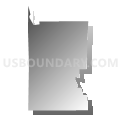
Maps


Graphs
Select a template below for downloading or customizing gragh for FORESTVILLE - T 2 Voting District, Door County, Wisconsin


Neighbors
Neighoring Voting District (by Name) Neighboring Voting District on the Map
- AHNAPEE - T 1 Voting District, Kewaunee County, WI
- BRUSSELS - T 2 Voting District, Door County, WI
- FORESTVILLE - T 1 Voting District, Door County, WI
- Forestville - V 1 Voting District, Door County, WI
- LINCOLN - T 1 Voting District, Kewaunee County, WI
Top 10 Neighboring County Subdivision (by Population) Neighboring County Subdivision on the Map
- Brussels town, Door County, WI (1,136)
- Forestville town, Door County, WI (1,096)
- Lincoln town, Kewaunee County, WI (948)
- Ahnapee town, Kewaunee County, WI (940)
- Forestville village, Door County, WI (430)